Land West of Clock Face Road, Clock Face
Public Consultation
Land at Clock Face Road, Clock Face
Public Consultation
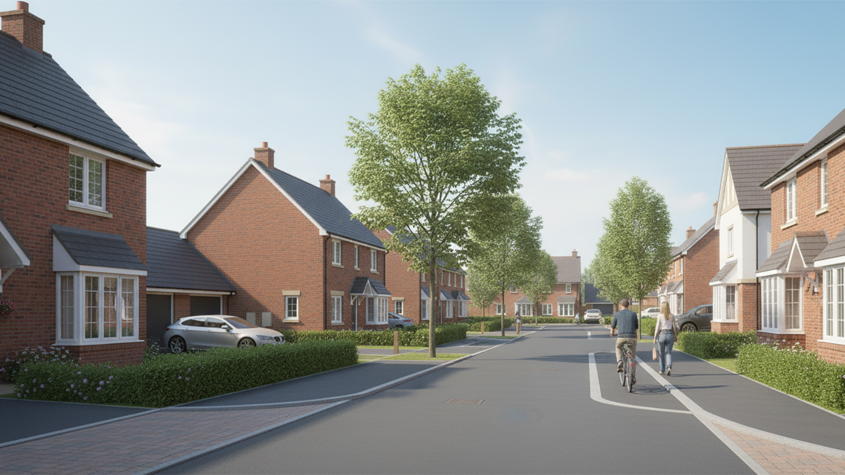
Welcome to Muller Property Group’s consultation on the draft proposals for development at Land West of Clock Face Road, Clock Face.
Welcome
We value the views of the local community and key stakeholders. All feedback received will be carefully reviewed and taken into account as we refine and shape our proposals.
Following this consultation, Muller Property Group intends to submit an Outline Planning Application to St Helens Borough Council for residential development with access from Clock Face Road.
Detailed matters such as layout and appearance will be addressed at a later stage through a subsequent planning application.
We would be grateful if you could take a few moments to review the information provided on this webpage and share your comments with us.
Please note that this consultation is being undertaken in addition to the statutory consultation that the Council will carry out once a formal planning application has been submitted.
Site Context
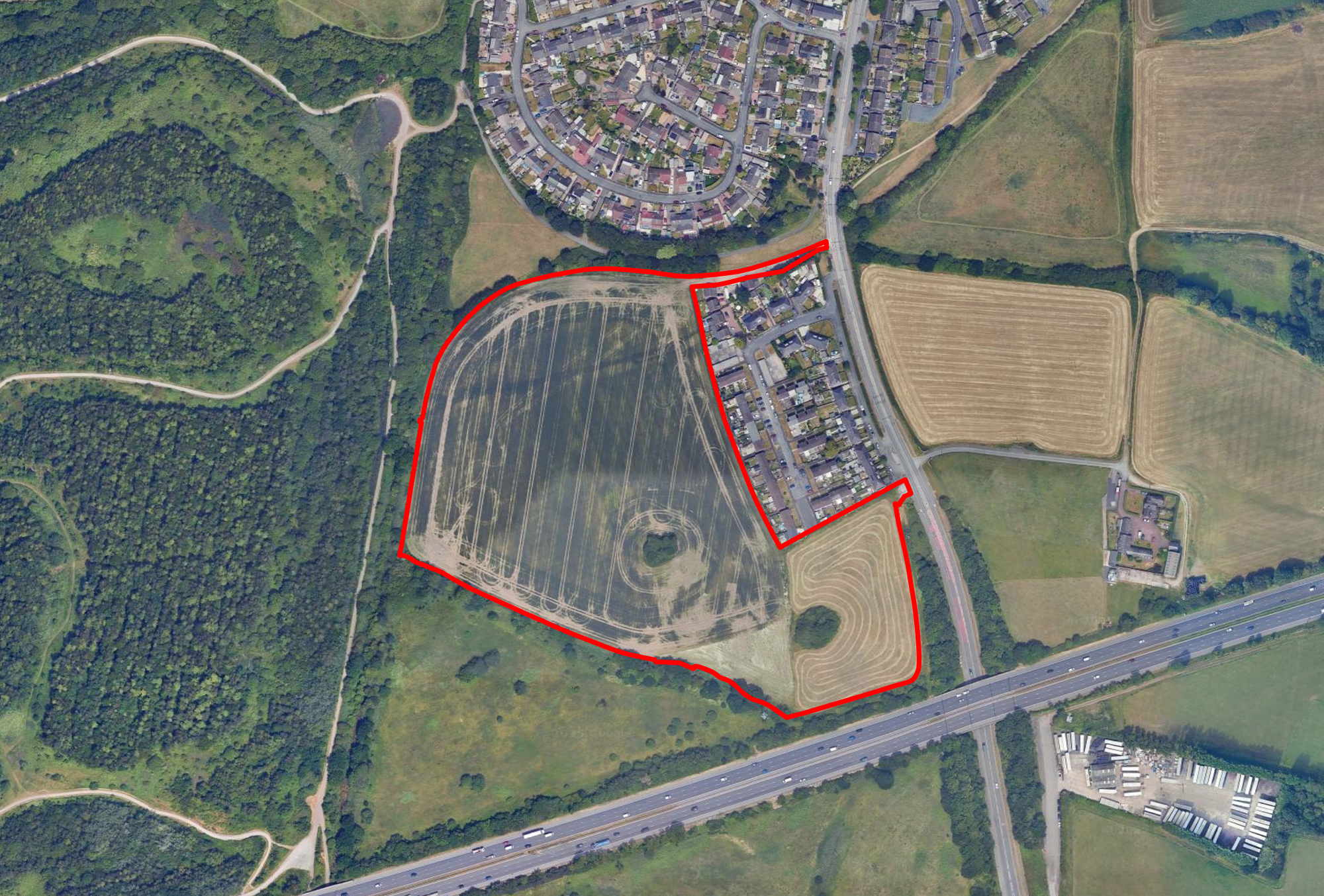
The Site extends to 8.5 hectares of agricultural land on the south-western edge of Clock Face.
While the Site currently offers limited ecological value due to the current agricultural use of the land, existing trees and hedgerows will be retained and enhanced where possible as part of future proposals.
The Site adjoins existing homes on Bridge Road and Sweet Brier Close, with the A569 (Clock Face Road) to the east and the M62 forming the southern boundary. The Site benefits from strong natural edges, including mature vegetation and nearby public open space.
To the north, the Miners Way footpath provides a recreational route along a former railway line, while to the west, a bridleway connects Clock Face with Farnworth and Bold. These routes offer excellent walking and cycling links, making the site highly accessible and sustainable for future development.
Bus Stop
Bus Stop
Bus Stop
M62
Bridge Road
Sweet Brier Close
Clock Face Road
Sutton Manor Woodland
Footpath
Miners Way Footpath
Miners Way Footpath
Bridleway
Interactive Site Location Plan
Click or hover over the location markers to view
Policy Context
Planning Policy Context
The site lies within the Green Belt, the boundary for which is very close to the edge of the site. In December 2024, the Government introduced new policies which allow for the release of Green Belt land, which would not cause sprawl, merging or impact historic towns, now defined as ‘Grey Belt’.
It is considered that the land meets the definition of ‘Grey Belt’, as less sensitive Green Belt land, and that the proposed development would fall within the acceptable forms of development in the Green Belt, subject to meeting the relevant requirements.
The Council’s 2018 Green Belt Assessment reviewed the site as part of a wider parcel of approximately 16 hectares, which included the public open space to the north and the adjoining field to the south-west. The assessment concluded that this parcel made “little or no contribution” (score 1) to the purposes of including land within the Green Belt.
Increased Housing Targets
Changes to the National Planning Policy Framework announced by the Government in late 2024 have increased the number of new homes St Helens Borough Council will need to deliver from 391 to 718 per annum.
This represents a significant increase compared to the previous housing requirement and local need figure. Evidence provided by the local planning authority indicates that the current housing land supply now falls below the five-year requirement, estimated at approximately 4.2 years of supply.
The adopted 2022 Local Plan only makes provisions for 65% of the Government’s Local Housing Need, and the council will need to start providing an additional 20% by July 2026 to make up the shortfall.
Emerging Proposals
We have created an illustrative masterplan showing how the proposed development could appear. It should be noted however that this is for illustrative purposes at this early stage in the outline planning process and is subject to change as a result of ongoing consultation and technical work.
Primary all modes access
from Clock Face Road
Active Travel access
from Sweet Brier Close
Landscaped focal green space to
provide visual focus and informal play
Existing hedgerows
and trees maintained
Existing hedgerows
and trees maintained
Existing hedgerows
and trees maintained
Existing hedgerows
and trees maintained
A mix of dwelling types, sizes and
tenures to create a balanced and
sustainable new community
Internal street trees
Existing ponds maintained and
nature enhancement opportunities
Opportunity for links to
connect open spaces
Interactive Masterplan
Click or hover over the location markers to view
Muller Property Group is proposing a residential-led development, which will assist the Council in meeting its need to deliver sufficient homes to meet identified demand.
The current proposals are illustrated on the Illustrative Masterplan Plan and will include:
- Around 200 new homes on land to the south-west of Clock Face, on a site previously assessed as making “little or no contribution” to the Green Belt.
- The delivery of housing in a sustainable and accessible location, making efficient use of land.
- The retention of existing trees, hedgerows and ponds on the site, allowing for ecological and habitat enhancements.
- New vehicular and pedestrian access off Clock Face Road, along with new pedestrian/emergency access from Sweet Briar Court.
- New pedestrian links connecting the development to surrounding public open spaces.
- A comprehensive landscaping strategy designed to visually enhance the site as a central component of the proposals.
- The creation of valuable amenity spaces and walking routes for both new and existing residents, while also supporting biodiversity.
- Areas of Public Open Space around the housing; including outdoor play provision for all ages.
- Housing which reflects the surrounding character of existing development in Clock Face.
- Provide a minimum of 45% of housing classified as affordable: for sale or rent at reduced values.
- A net increase in Biodiversity of at least 10% when compared with the current ecological value of the site.
Technical Work
We have already undertaken a range of technical work on the site to inform how we design the scheme and raise any constraints we need to consider. These have been assessed through a series of initial surveys and other assessments.
Our technical work will be expanded upon within the forthcoming planning application submission, which will include the following:
- Landscape and Visual Impact Assessment
- Transport Assessment
- Ecology, Biodiversity Net Gain Analysis
- Drainage Assessment
- Contaminated Land Survey
- Noise Survey
- Tree Survey
Transport and Access
The proposals include a new vehicular access from Clock Face Road to the south-east, which will serve as the main entrance to the development and connect to a primary street running through the site.
The masterplan promotes sustainable movement, with a network of walking and cycling routes integrated throughout the development via a connected pattern of streets and footpaths. This approach encourages active travel and healthy living, making it easier for residents to walk or cycle to nearby destinations. An additional pedestrian and emergency access is also proposed to the north via Sweet Briar Court, improving permeability and connectivity.
The site is highly sustainable, located within convenient walking and cycling distance of local services and facilities. It is also well served by public transport, including the frequent 29 bus route between St Helens and Rainhill, while the nearby M62 provides quick access to the wider area, including Liverpool.
Landscape
The landscape strategy will be designed to integrate a range of elements that enhance the environmental quality, biodiversity, and visual character of the development.
Generous landscaped spaces will be incorporated throughout the site, providing public open space, supporting biodiversity, and the retention of existing ponds.
Native planting will be used extensively to strengthen local habitats and improve the site’s visual setting.
A suite of information will be submitted with the application including an Ecological Impact Assessment, Arboricultural Surveys, and species-specific ecology surveys.
Flood Risk and Drainage
The site lies within Flood Zone 1, indicating the lowest risk of flooding, with less than a 1 in 1,000 annual probability of river or sea flooding.
The planning application will address all relevant flood risk and drainage considerations, incorporating sustainable drainage systems throughout the development, with water released from the site at a controlled rate, ensuring no increased risk of flooding in the locality.
A detailed drainage strategy and a Flood Risk Assessment will be submitted with the planning application.
Benefits
The proposals would bring a number of benefits for Clock Face and the wider St Helens area, including:
Affordable Housing
Enabling social mobility by providing 45% affordable homes.
Economic Boost
The creation of jobs and opportunities for local suppliers during development, plus increased local spending once homes are occupied.
Green Space & Play Areas
Retaining trees, hedgerows and creating New areas of Public Open Space for recreation and leisure.
Visual Enhancements
Comprehensive landscaping strategy designed to create a visually pleasing site.
Wildlife and the Environment
A commitment to deliver a 10% biodiversity net gain.
Addressing local housing need
Helping to meet the local area’s identified requirement for new homes by providing around 200 new homes as a balanced mix of housing types and sizes.
Have Your Say
To provide your feedback on the proposals, you are welcome to complete the consultation questionnaire below or you can submit comments via:
Completing the online feedback form
Email: land@muller-property.co.uk
using the title ‘Clock Face Consultation’
within the subject line of the email.
Call: 0800 788 0900
(Monday to Friday: 9:00am to 5:30pm)
Post: Ref: Clock Face, Muller Property Group, The Point, Crewe Road, Alsager, Cheshire, ST7 2GP
Please provide your comments by 5th December 2025.
Frequently Asked Questions
We have addressed some common questions about our emerging proposals. We will continue to review, update and add to the FAQs as the consultation moves forward and through the planning process.
Why is the development being proposed?
There is a well-documented housing shortage across the UK, and Councils are required to allocate land to meet local housing needs. St Helens Borough Council is currently unable to demonstrate an adequate supply of housing, highlighting the need for well-planned, sustainable development. The site will contribute to meeting this demand, delivering high-quality homes while enhancing the local area.
Why is this site being considered for housing?
The Council’s 2018 Green Belt Assessment reviewed the site as part of a wider parcel of approximately 16 hectares, which included the public open space to the north and the adjoining field to the south-west. The assessment concluded that this parcel made “little or no contribution” (score 1) to the purposes of including land within the Green Belt.
We consider that the site meets the definition of Grey Belt land and as such the proposal would not undermine the overall function of the Green Belt.
How many homes are proposed?
We are proposing around 200 new homes, with a mix of sizes and styles.
Will there be affordable housing?
It is proposed that 45% of the new homes delivered on the site will be affordable homes, in line with local policy requirements.
What about the environment?
Protecting and enhancing the environment lie at the core of our proposals, retaining existing trees, hedgerows, and ponds, among new planting and the creation of public open space. Our measures will achieve at least a 10% biodiversity net gain.
What about traffic and access?
Access is proposed from Clock Face Road. A Transport Assessment is being prepared to make sure the development can be accommodated safely.
What is an outline planning application?
An outline planning application is the first stage of the planning process. It seeks approval for the principle of development – in this case, around 200 new homes on the site, along with the main access point.
Next Steps
Thank you for taking the time to participate in this community consultation. Your feedback is greatly valued, and all comments received will be carefully considered.
As part of the forthcoming Outline Planning Application, a Statement of Community Involvement will be prepared to summarise the feedback received and explain how it has informed the proposals.
Muller Property Group intends to submit the planning application to St Helens Borough Council later this year.
Once the application has been registered by the Council, there will be a further opportunity for residents and stakeholders to provide comments through the Council’s formal consultation process.
Land West of Clock Face Road, St Helens
Land at Clock Face Road, Clock Face